


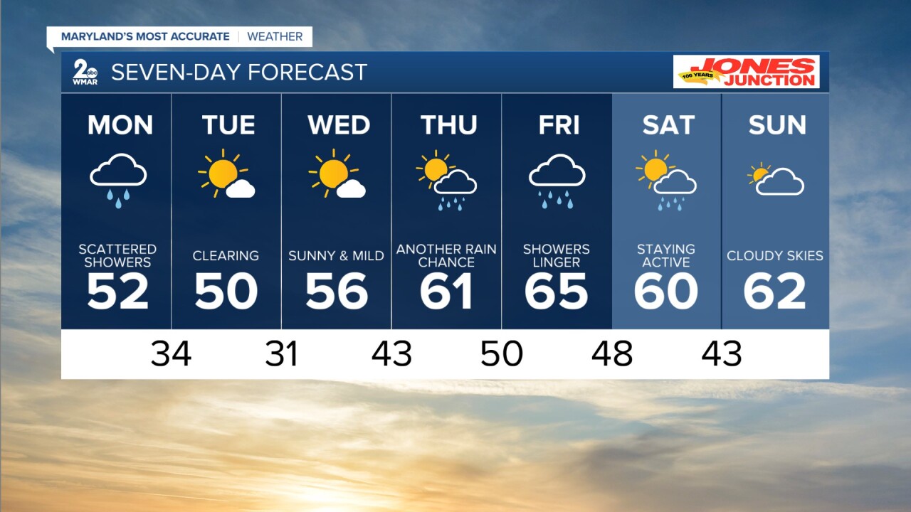
BALTIMORE — Scattered showers fill in Sunday evening and into the overnight hours. Most of the rain is expected to fall into early Monday morning. There will be enough lingering moisture for patchy fog to develop too. Some rain sticks around Monday afternoon, but it gradually becomes more widespread. Temperatures drop big time. We are looking at readings in the low 50s for highs and mid 30s to near freezing for lows! It is a break from the rain for a few days with sunny skies on Tuesday and Wednesday. Showers are back Thursday and Friday as highs surge into the 60s. Some rain is with us to start the weekend, but Sunday is looking dry for now.
Tonight Rain, mainly after 7pm. Patchy fog between 10pm and 5am. Low around 41. Northeast wind around 8 mph.
Monday Rain, mainly before 11am. Patchy fog before 1pm. High near 52. Northeast wind 6 to 8 mph.
Monday Night A slight chance of showers before 2am. Patchy fog between 9pm and midnight. Otherwise, cloudy, then gradually becoming partly cloudy, with a low around 34. Light west wind becoming northwest 8 to 13 mph in the evening. Winds could gust as high as 18 mph.
Tuesday Sunny, with a high near 50. Breezy, with a northwest wind 15 to 20 mph, with gusts as high as 34 mph.
Tuesday Night Mostly clear, with a low around 31.
Wednesday Sunny, with a high near 56.
Wednesday Night Partly cloudy, with a low around 43.
Thursday A chance of showers. Mostly cloudy, with a high near 61.
Thursday Night Showers likely, mainly before 2am. Mostly cloudy, with a low around 50.
Friday Showers likely. Mostly cloudy, with a high near 65.
Friday Night Showers likely. Mostly cloudy, with a low around 48.
Saturday A chance of showers. Partly sunny, with a high near 60.
Saturday Night A chance of showers. Mostly cloudy, with a low around 43.
Sunday Mostly cloudy, with a high near 62.
