


BALTIMORE — Steady snow continues overnight and into Tuesday morning. This when most of the snow will fall. When it is all said and done, totals will be in the 4-5" range. A few isolated spots could get closer to 7". This has prompted a winter storm warning for most of our area. A few exceptions are the eastern shore. Allow for extra time to clear your car and driveway Tuesday morning. Any untreated roads or walkways will be slick. Snow gradually tapers off mid morning. We could see a change over to some ice as temperatures climb, but impacts look low at this point. Colder air is in place for the rest of the week. We will watch another snow chance by Friday. Into the weekend overnight lows drop into the teens. It will be a bitter cold start for a few days. Highs slowly climb back into the 30s late weekend into next week.
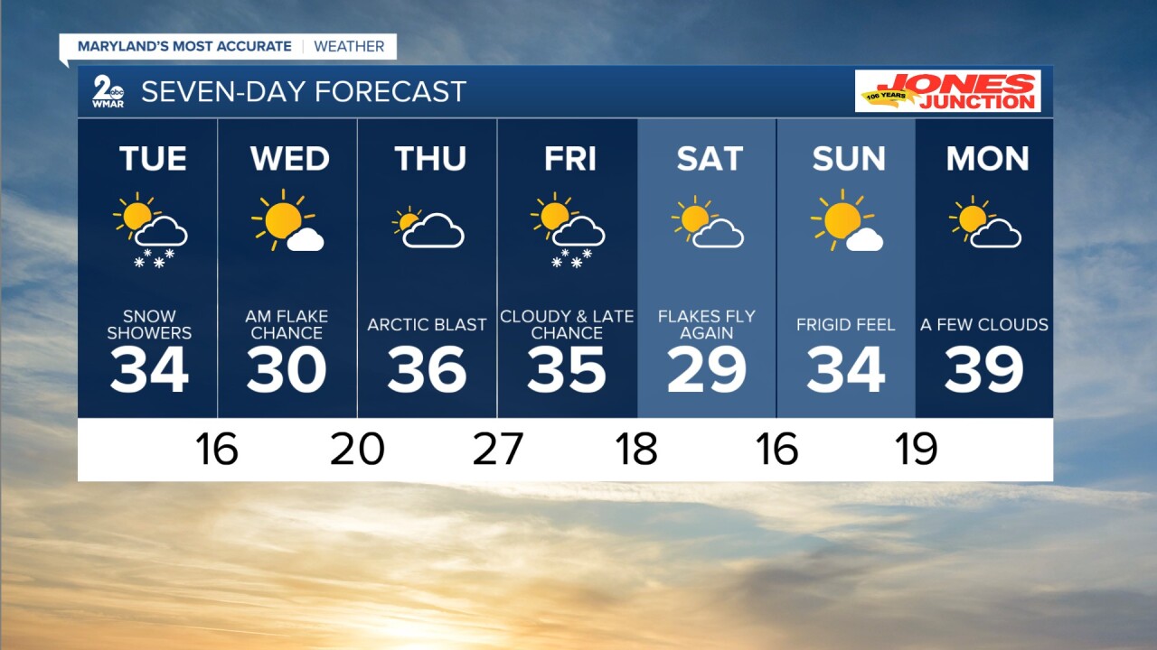
7 Day Forecast:
Tonight Snow before 4am, then snow, possibly mixed with freezing rain. Low around 28. East wind around 5 mph.
Tuesday Snow likely before 10am, Cloudy, with a high near 34. Northeast wind 5-15 mph becoming northwest in the afternoon.
Tuesday Night Mostly clear, with a low around 16.
Wednesday Sunny, with a high near 30.
Wednesday Night Partly cloudy, with a low around 20.
Thursday Cloudy, with a high near 36.
Thursday Night A chance of snow. Cloudy, with a low around 27.
Friday A chance of snow. Mostly cloudy, with a high near 35.
Friday Night Partly cloudy, with a low around 18. Blustery.
Saturday Partly cloudy, with a high near 29. Blustery.
Saturday Night Mostly clear, with a low around 16. Blustery.
Sunday Mostly sunny, with a high near 34. Breezy.
Sunday Night Mostly clear, with a low around 19.
Monday Partly cloudy, with a high near 39.
