


BALTIMORE — We are keeping skies dry, humidity values low, and highs in the mid to upper 80s through Wednesday. A few more clouds on Wednesday are possible as our next system approaches. An isolated strong to severe storm is possible on Thursday. The Storm Prediction Center has the entire area under a Marginal Risk (level 1/5) as damaging winds could be the top concern. I don't think July 4th is an all-out washout, but be mindful of the radar and storm potential. Highs will return into the mid-90s and it will feel near triple digits late-week. The 90°+ high streak sticks around through the weekend with scattered showers and thunderstorms this weekend into the early
workweek.
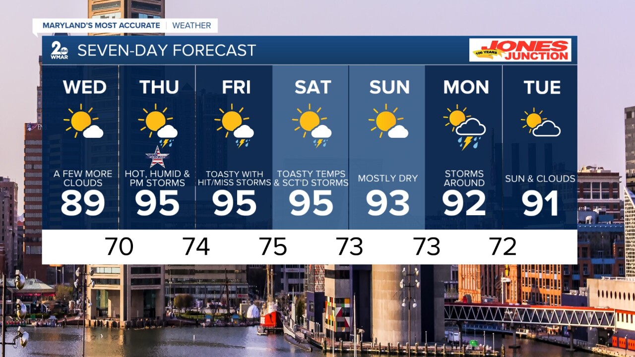
7 Day Forecast:
Tonight Mostly clear, with a low around 65. Southeast wind 5-10 mph.
Wednesday Sunny, with a high near 89.
Wednesday Night Partly cloudy, with a low around 70.
Independence Day A chance of showers and thunderstorms. Partly sunny, with a high near 95.
Thursday Night A chance of showers and thunderstorms. Mostly cloudy, with a low around 74.
Friday A chance of showers and thunderstorms. Partly sunny, with a high near 95.
Friday Night A chance of showers and thunderstorms. Mostly cloudy, with a low around 75.
Saturday A chance of showers and possibly a thunderstorm. Partly sunny, with a high near 95.
Saturday Night Showers and thunderstorms likely. Mostly cloudy, with a low around 73.
Sunday Mostly sunny, with a high near 93.
Sunday Night Partly cloudy, with a low around 73.
Monday A chance of showers and thunderstorms. Mostly sunny, with a high near 92.
Monday Night Partly cloudy, with a low around 72.
Tuesday A chance of showers and thunderstorms. Mostly sunny, with a high near 91.
